getting on with my Ridgeway project!
So a bit of a drive (....frustratingly finding myself
touching on bits of Swindon on the way, which I had
no desire to do! Grrrrr!) brought me eventually
to the village of Berwick Bassett, where I left my car.
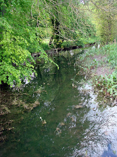
From here I more or less followed the course of a stream
towards Winterbourne Bassett
(not a hound in sight by the way!)
and then out towards Windmill Hill,
the last of the prehistoric features in the vicinity
of Avebury.
This site is a "classic Neolithic 'causewayed enclosure'"
apparently. More about it here: http://www.britarch.ac.uk/ba/ba67/feat3.shtml
I must admit to not being very excited about
this spot, but anyhow at least now
I know what it's like....
Whilst enjoying a skylark singing I enjoyed a view
towards "yonder hills" onto which I then progressed
via Avebury....

and onto the.....

As I mentioned, it was a windy day and I walked
for the most part with the wind buffeting me from
off to my right. The bright blue sky, with the bright
yellow of flowering oil-seed rape, the bright chalky
whiteness of the path ahead and the grassy pastures
gave me something of a feeling between sensory overload
and sensory deprivation (if that makes any sense).
Anyway, here is an artst's impression (without the wind!)!!!

The spartan landscape at this point is relieved by
the three clumps of beach trees (as seen afar off in tyhe
topmost photo). I also passed close to another white houre
at Hackpen Hill, but I failed to spot it. It is not a tremendously
old one anyway (1830's)
Then with lunchtime approaching, I ascended a small slope
to Badbury castle (hill fort) which stands as if guarding
the westward entrance to a small valley running down towards
Marlborough. As another welcome role its "ramparts" gave me
temporary relief from the wind, to unwind listening to skylarks
once more, eat some lunch....

and admire the wildflowers that also sheltered here,
away from the ravages of high intensity agriculture.
A speedwell

Another attractive little blue flower.....
any suggestions????

Ah! These I know...cowslips!

Kidney vetch?


Time to move on.....
Leaving Barbury Castle behind I headed out
along Smeathe's Ridge where a stretch of open
access land is being grazed in ways to return it
to old-style chalk-land - with a reasonably full assembly
of wildflowers and wildlife one hopes. Not much in
that way evident at the moment, however.

The ridge took me down eventually, and to my relief,
out of the wind and into some blessed shade from trees
and hedges in the small valley I refered to earlier.
This valley was formed, it seems by the gentle
erosion of the river Og, a tributary stream to the Kennet,
and thence to the Thames

the valley has a cluster of villages named by it...
Ogbourne St. George, Ogbourne St. Andrew,
and Ogbourne Maizey. They are olde style villages
of the thatch cottage ilk.
I had had thoughts of walking through each of these
(leaving the Ridgeway path for today)
downstream into Marlborough and along the canal
for some scenic contrast. But time and wearines
now constrained me and I took a more direct path
now constrained me and I took a more direct path
which took me passed Barton Down Gallops and
across Fyfield Down.

This latter spot is a a National Nature Reserve
and is, in essence the quarry site for Avebury
and (most of) Stonehenge. Before doing a little
research on this stone formation I thought
the rocks strewn across the landscape
had been dragged there by labourers on the
stone circle from some other far off place.
This notion arose partly from memories of
visiting the Presselli mountains where the rest
of Stone Henge was quarried, and partly from
geological ignorance of any solid rocks which could
have overlain chalk (which I think is an excusable error!)
Apparently greywether stone is formed from sandstone
glued together ("indurated") with silica in the Tertiary period.
The overlying softer sandstone has largely gone but these more
solid chunks remained and have been shuffled about on the surface
during glacial episodes. In places they form a "river of rocks"
as they slither down into chalky valleys.
Like shown here:
http://www.megalithic.co.uk/modules.php?op=modload&name=a312&file=index&do=showpic&pid=3671
http://www.megalithic.co.uk/modules.php?op=modload&name=a312&file=index&do=showpic&pid=3671
The grey wethers are also significant, apparently,
for the communities of lichens that grow on them.
Like these, I guess! (shrugs shoulders)

In another part of the reserve the grey wethers
create a natural rock garden amidst the trees.

Leaving Fyfield Down I followed a path back onto
the ridgeway path briefly before descending the
slope near Berwick Bassett clump, then along a
slighty uncomfortable bit of busy road finally to bring me
back to my car. 8 well figured!

No comments:
Post a Comment